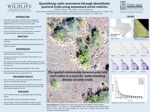
The purpose of this study is to quantify livestock pasture use in a pasture used by identifying cattle trails using unmanned aerial vehicles (UAVs). Our study site was located on a 95.5-hectare private ranch in Jim Hogg County, Texas, USA. In corporation with drone imagery, software such as Pix4D Mapper and ArcGIS Pro were used to stitch our 2D orthomosaic model and outline all identifiable cattle trails. Due to the limited research in utilizing cattle trails to quantifying animal movement. Our objectives are to 1) determine the feasibility of quantifying livestock trails in a pasture and 2) quantify the effect of scale on the evaluation of line densities. The findings of our study will contribute additional research towards understanding the relationship between cattle mobility and resource availability. Identifying the relationship is needed in order to implement better land management techniques and biodiversity conservation of our agricultural landscapes.
Faculty Mentor: Dr. Humberto Perotto
Department of Range and Wildlife Sciences